Tree Rings Offer an Insight into the Spatial-temporal Patterns of Hydroclimate Change on the Chinese Loess Plateau and Disclose the Role of NHT in the 1920s Drought
The Chinese Loess Plateau (CLP) is in the central part of northern China and covers the entire middle reaches of the Yellow River. It is known as the cradle of Chinese civilization. The climate aridity since the mid-20th century has raised concerns about water resources on the CLP. It remains unclear whether or not the current arid state of the CLP is unprecedented, and the spatial-temporal characteristics of hydroclimatic variability across the CLP over past centuries are not well understood. In addition to the influence of the Asian summer monsoon system, what role do other factors, such as the Northern Hemisphere temperature (NHT), play in a drought event?
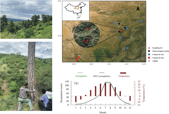
Recently, a research group from the Institute of Earth Environment of the Chinese Academy of Sciences (IEECAS) reconstructed a regional hydrological-year precipitation from 1773 to 2020 in the Heichashan Mountains, which was representative to the hydroclimatic variation on the eastern CLP over the past 250 years.
The study was published in Science of the Total Environment on August 18.
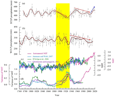
The reconstruction revealed that the 20th drying trend had been reversed since the early 2000s, and 2014–2020 CE had been the second wettest period over the past 250 years. 1910–1932 CE was the longest and driest period over the past centuries. At the decadal scale, the 1920s was the driest decade, whereas the 2010s was the wettest decade. At the centennial scale, the 19th century was relatively wet, whereas the 20th century was comparatively dry. It was demonstrated that droughts tend to occur in warm periods.
The researchers disclosed that hydroclimate had changed synchronously on the eastern and the western CLP for most of the past two centuries. However, east-west regional differences existed in the 1890s–1920s drying process and in the timing of the onset of the 20th-century aridity.
This work also highlights a major finding that the 1920s megadrought may be related to a regime shift in NHT.
This work was supported by the Strategic Priority Research Program of Chinese Academy of Sciences (XDB40010300), the Marine S&T Fund of Shandong Province for Pilot National Laboratory for Marine Science and Technology (Qingdao) (2022QNLM050202), the National Natural Science Foundation of China (41630531), the National Observation and Research Station of Regional Ecological Environment Change and Comprehensive Management in the Guanzhong Plain, Shaanxi and the State Key Laboratory of Loess and Quaternary Geology.

Fig. 1 Overview of the study area and the sampling environment (Image by CAI, et al)

Fig.2 Comparison of hydrological-year precipitation in the east (a, this study) and the west (b, Liu et al., 2019) of the Chinese Loess Plateau, and the relationship between 1920s drought and Northern Hemisphere temperature (NHT, c, d) (Image by CAI, et al)
Contact: Bai Jie, Institute of Earth Environment, Chinese Academy of Sciences, Xi'an, China. Email: baijie@ieecas.cn
 © 2015 Institute of Earth Environment,CAS
 Address:No. 97 Yanxiang Road, Xi'an 710061, Shaanxi, China

 Location :