Dramatic water-level changes have occurred in most lakes across the Tibetan Plateau (TP), leaving behind a series of paleo-shorelines. However, the timing of maximum lake expansion on the TP remains unclear.
Early radiocarbon dating reveals that maximum lake expansion occurred during MIS 3(ca. 29-57 ka), while recently, an increasing number of OSL ages have demonstrated that the maximum lake expansion might have occurred during MIS 5(ca. 71-130 ka). Independent confirmation of the timing of paleo-shorelines beyond 50 ka is especially important as studies that rely on 14C dating are limited to about the past 50 ka, due to the 14C half-life (5,730 years).
Other than 14C and OSL, the amounts of terrestrial in situ cosmogenic nuclides (TCN), including10Be, 26Al and others, produced by the interaction of secondary cosmic rays with target elements in the upper few meters of earth-surface materials have been proven reliable in dating lake paleo-shorelines ranging from 102 to 106 years with limited number of studies on the TP.
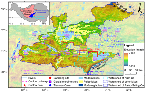
Recently, a study led by Prof. ZHOU Weijian from the Institute of Earth Environment (IEE) of the Chinese Academy of Sciences investigated Nam Co lake terraces based on cosmogenic 10Be and 26Al exposure dating.
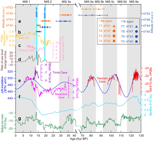
After sensitivity analysis of TCN exposure dating results from geological processes considering both inherited TCN and subaerial erosion, they revealed that the ages of four high Nam Co stands marked by terraces (T7, T6, T5, and T4) were 81.5±9.0 ka, 33.6±1.9 ka, 19.9±1.9 ka, and 15.2±0.4 ka. The topographically highest terrace, T7 supported an MIS 5 maximum lake expansion on the TP, as opposed to MIS 3.
Moreover, compared with surrounding lakes and paleoclimate archives, they demonstrated that there was no geological evidence to support the existence of a giant East Qiangtang Lake (EQL) that would have connected Nam Co, Siling Co and other big lakes during MIS 5.
These findings not only laid a solid foundation for the assessment of TCN-exposure ages from lake terraces but also revealed the lake level fluctuations of Nam Co associated with climate change and contribute to a more detailed understanding of maximum lake expansion across the TP.
This work, published in Quaternary Science Reviews, was jointly supported by Key Research Program of Frontier Sciences, CAS, the international partnership program of Chinese Academy of Sciences , the National Natural Science Foundation of China via grants, CAS “Light of West China” Program and the MOST special fund for State Key Laboratory of Loess and Quaternary Geology.

Fig.1. Advanced Land Observing Satellite (ALOS) digital elevation model (DEM) (Tadono et al., 2014) of Nam Co and Siling Co watersheds. Modern and paleo-lake extents are shown in blue and yellow, respectively. Outflow pathways are shown as purple lines. Glacial moraine sites are shown as purple squares. (Imaged by ZHOU Jie, et al.)

Fig.2. Paleoclimate records compared with the Nam Co 10Be- and 26Al-based terrace chronology. (a) Nam Co 10Be and 26Al exposure ages, after rejecting potential outliers. (b) Pollen Discriminant Index (PDI) from Nam Co lacustrine core (Zhu et al., 2015). (c) Chironomid based summer temperature record from Tiancai Lake (Zhang et al., 2019). (d) Rate of ice-volume equivalent sea-level change (Lambeck et al., 2014). (e) ISM-related stalagmite δ18O records from Timta cave (purple) (Sinha et al., 2005), Mawmluh cave (magenta) (Dutt et al., 2015), Tianmen cave (red) (Cai et al., 2010) and mean JJA insolation at 30°N (blue) (Laskar et al., 2004). (f) LR04 stack of marine benthic foraminiferal δ18O records (Lisiecki and Raymo, 2005). (g) δ18O records from Guliya ice core, West Kunlun (Thompson et al., 1997). (Imaged by ZHOU Jie, et al.)
Contact: Bai Jie, Institute of Earth Environment, Chinese Academy of Sciences, Xi'an, China. Email: baijie@ieecas.cn
 © 2015 Institute of Earth Environment,CAS
 Address:No. 97 Yanxiang Road, Xi'an 710061, Shaanxi, China

 Location :