Understanding the dynamics and variability of the paleo East Asian Summer Monsoon (EASM) system is crucial to discuss spatiotemporal monsoon rainfall patterns in East Asia and future climate projections.
However, paleoclimate records currently lack sufficient geographic detail to understand the spatiotemporal evolution of EASM rain belt since the late Pleistocene. In particular, there is no consensus on whether the EASM rain belt reached its modern northern limit by the early Holocene.
Recently, a study led by Prof. ZHOU Weijian from the Institute of Earth Environment (IEE) of the Chinese Academy of Sciences investigated a high-resolution, absolute-dated lacustrine-eolian record from the central Hunshandake sandy land (Hunshandake), on the northernmost margin of the EASM-affected region.Their study was published in Quaternary Science Reviews.
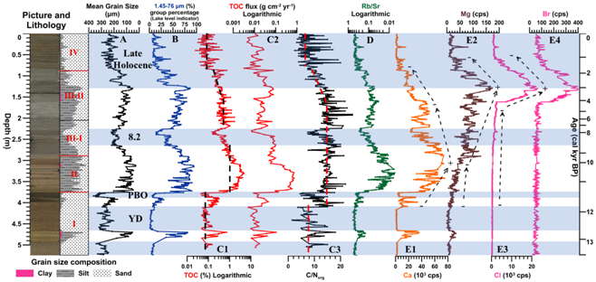
They found that moisture conditions at this site became markedly wetter at ~11.7-11.5 ka, at the onset of Holocene Epoch. Maximum moisture conditions occurred at ~11.3-8.5 ka. Wet conditions generally prevailed for the first half of the Holocene, then became progressively drier since ~4.2 ka.
Their findings supported the view that the EASM rain belt reached its modern northern limit, at least to the Hunshandake, during the early Holocene. They also compared their results with published records from the northern EASM margin, and lay out that the interplay between the monsoon and Westerlies, chronologic uncertainties and/or variable climate proxy sensitivities partly explained the differences. Regional factors, including land-surface and vegetation feedbacks, were also likely important.
Moreover, they observed several distinct sub-orbital scale climatic events in the lacustrine-eolian sequence during the late Pleistocene?Holocene transition. These included the Younger Dryas (YD) and 8.2 ka climate reversals. Wetter climate (11.7-11.5 ka, 406-386 cm depth), followed by abrupt reversal (11.5-11.3 ka, 386-375 cm depth) during 11.7-11.3 ka, was observed. These events correlated well with post YD warming and the pre-Boreal oscillation in Greenland ice record.
They interpreted the orbital scale moisture variation at this study site to the changes in insolation, assigning these abrupt and short-lived changes during the late Pleistocene-Holocene transition to a persistent teleconnection between the North Atlantic and east Asian climate zones.

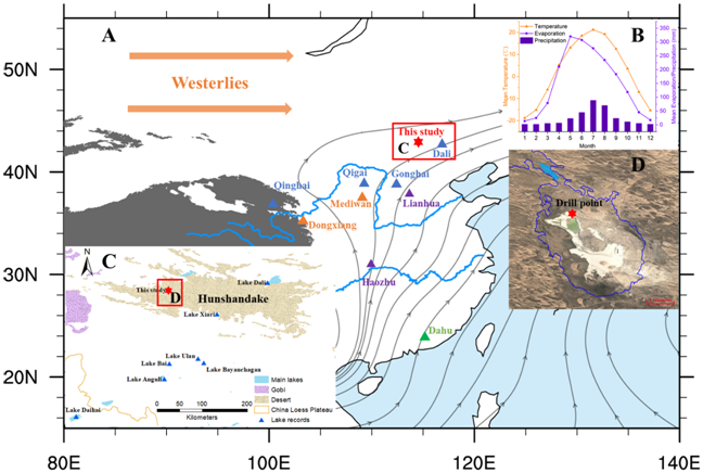
Fig. 1. Geological setting of the study site (red solid star, Lake Bayan nuur, 43°07′N, 114°30′E, 1070 m).(A) Averaged atmospheric flow fields at the 850 hPa isobar in summer (JJA) from 1971 to 2010;(B) Meteorological observations from Xilinhot station (1971-2000);(C) Geological setting of Hunshandake;(D) Satellite view of Lake Bayan nuur.(Imaged by MING Guodong, et al.)

Fig.2 Stratigraphy and parameter measurements results of the lacustrine?eolian sequence from Lake Bayan nuur. (Imaged by MING Guodong, et al.)
Contact: Bai Jie, Institute of Earth Environment, Chinese Academy of Sciences, Xi'an, China. Email: baijie@ieecas.cn
 © 2015 Institute of Earth Environment,CAS
 Address:No. 97 Yanxiang Road, Xi'an 710061, Shaanxi, China

 Location :