Shandong Peninsula is the largest peninsula in China. At present, the water depth of the Bohai Sea and Yellow Sea adjacent to Shandong peninsula is less than 100 meters. The melting of the global ice sheet can cause the sea level rise more than 120 meters during the transition from glacial maximum to interglacial, resulting in huge coastline shifts in Eastern China. The coastline shifts and associated changes in sea-land configuration have profound impacts on the regional lower boundary conditions, dust outputs, monsoon precipitation and its oxygen isotope composition, highlighting this region to be a key area for studying the connections of regional and global climate changes during the deglaciation. Therefore, figuring out the history of regional precipitation and its isotopic composition as well as its dynamics on glacial-interglacial scale, is one focus of paleoclimate change study in East Asia.
Recently, the research team led by Prof. CAI Yanjun from the Institute of Earth Environment, Chinese Academy of Sciences, reported a precisely U-series dated and high-resolution analyzed isotope record during the penultimate deglacial, attained from a stalagmite SD1 from Shangxiaofeng Cave, Shandong Province. The results revealed that there was a weak monsoon event lasting 400 years around 128.3ka BP. Corroborated with other records which also documented such event during penultimate deglacial, they suggested that this weak monsoon event/cold event does broadly existed in the northern hemisphere and this YD-like event was likely an intrinsic feature of climate change during the ice age terminations, further substantiating the teleconnection between North Atlantic climate changes and variations of Asian summer monsoons.
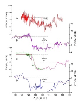
Moreover, the research group also found that the difference of Shangxiaofeng Cave speleothem δ18O between glacial and interglacial is ~0.7‰, which was significantly smaller than those of speleothem records in southern China (Yangkou Cave is~1.4‰, Dongge Cave is ~2.2‰, Sanbao Caveis ~2.4‰). They then proposed that this disparity was largely caused by the coastline shift in Eastern China. That is, during the glacial maxima, the sea level was about 120 meters lower than present, and the Bohai Sea, Yellow Sea and large of the East China Sea would be exposed as land, the distance from the study cave to ocean increased substantially, i.e., from the current 100 kilometers to more than 800 kilometers. The dramatically increased distance from ocean moisture source to cave site and the continual condensation of ocean water vapor would likely result in deficit of 18O and deplete the precipitation δ18O, namely, the “continental effect” is significantly enhanced. This depletion leaded to the muted contrast of precipitation δ18O between glacial and interglacial periods. Meanwhile, changes in sea-land configuration also altered the regional atmospheric circulation, resulting in varied contributions from different moisture sources, rendering another possible factor contributing this disparity. As stated by the authors, this study also provided a new perspective on the interpretation of the oxygen isotope record of stalagmites in coastal areas of Eastern China.
This work was supported by the National key research and Development Program of China "Asian Monsoon Variation and Mutation Event" (2017YFA0603401) and the Chinese Academy of Sciences (grant XDPB05),and this work recently was published in an international journal Quaternary Science Reviews.

Fig.1 The comparison between our speleothem record (red) and other various records during the penultimate deglaciation, the vertical yellow bar indicates the YD-like event in various sediments. (Image by Cai, et al)

Fig.2 The δ18O difference between penultimate glacial and interglacial period of (A) our record, (B) Dongge Cave; (C) Sanbao Cave; (D) Yangkou Cave. (Image by Cai, et al)
Contact: Contact: Bai Jie, Institute of Earth Environment, Chinese Academy of Sciences, Xi'an, China. Email: baijie@ieecas.cn
 © 2015 Institute of Earth Environment,CAS
 Address:No. 97 Yanxiang Road, Xi'an 710061, Shaanxi, China

 Location :