Southeastern Tibetan Plateau (TP) is the cradle and/or upper reaches of many large rivers in Asia. This region is also the refuge of many animals and plants since Pleistocene with a high-biodiversity ecosystem. The runoff changes of these rivers have important impacts on the social and economic development as well as the ecosystem of southwestern China and Indo-China Peninsula. Understanding the variability and mechanisms of historical monsoon precipitation in southeastern TP on centennial-to decadal-timescales especially during historical warm periods is important for evaluating future trends of runoff changes of these large rivers.
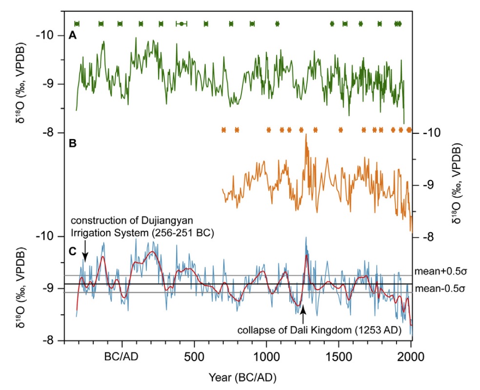
Dr. TAN Liangcheng, from the Belt & Road Center for Earth Environment Studies, Institute of Earth Environment, Chinese Academy of Sciences, collaborated with his colleagues, reconstructed high-resolution (~4.9 yrs) monsoon precipitation variations in southeastern TP over the past 2300 years by using stalagmite δ18O records from Shenqi (SQ) cave in southern Sichuan, China.
The results revealed an overall decreasing precipitation trend, with two most notable wet periods occurred in 60-280 AD and 370-510 AD. The most remarkably dry period is the recent 200 years. Some decadal scale dry intervals occurred in 10 BC-35 AD, 740-840 AD, 1160-1245 AD, and 1550-1590 AD. The further research indicated a relative wet climate and frequently changed rainfall during the first half of the 3rd century BC before the construction of the Dujiangyan irrigation system. The abnormal droughts during 1160-1245 AD in southeastern TP, where Dali kingdom's political center located, might have seriously weakened its national power, and accelerated its collapse (1253 AD). Power spectrum analysis indicated significant 373-, 187-, 22-, 12- and 11- yr cycles in stalagmite record, suggesting the impact of solar activity. Increased monsoon precipitation on southeastern TP was observed in solar activity minima during the last millennium.
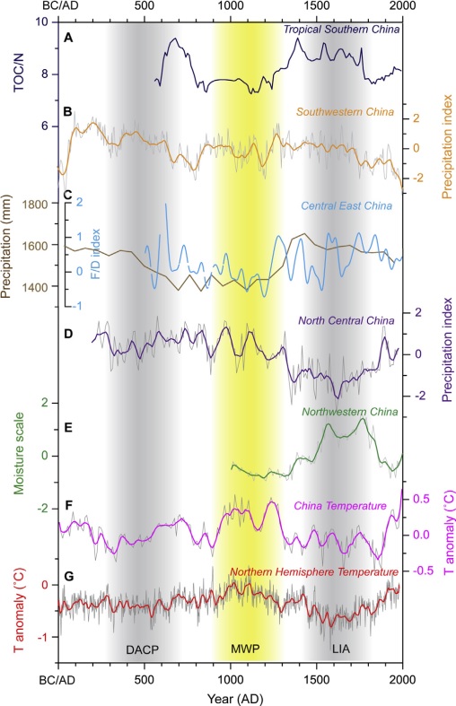
The scientists further synthesized an integrated precipitation record for southwestern China and discussed spatial patterns of precipitation over China during the last two millennia. The results confirm a “dry southern and wet northern” pattern in monsoonal China in warm periods on centennial scale but a “wet southern and dry northern” pattern in cold periods during the last 2000 years. Solar activity, the strength of westerly jet and summer monsoon, as well as the sea surface temperature (SST) of tropical Indo-Pacific might play important roles on the rainfall spatial patterns over monsoonal China during the last 2000 years.
This study was recently published in Quaternary Science Reviews. The work was funded by the Shaanxi Science Fund for Distinguished Young Scholars (2018JC-023), National Key Research and Development Program of China (2017YFA0603401) and Youth Innovation Promotion Association of Chinese Academy of Sciences (2012295). This study is a part of the “Belt & Road” project of IEECAS.

Fig.1 δ18O records of (A) SQ1 and (B) SQ7. The curve in panel C is the combined SQ δ18O record..(Image by TAN, et al.)

Fig.2 Comparisons of (B) synthesized precipitation record of southwestern China with (A) TOC/N ratio record from Huguang Maar lake, (C) blue line-historical Flood/Drought (F/D) record of east-central China, brown line-pollen reconstructed rainfall record from Dajiuhu peat land in central China, (D) synthesized precipitation record of north-central China, (E) synthesized moisture record of arid northwest China, (F) temperature (T) anomaly of China, and (G) temperature anomaly of northern hemisphere.(Image by TAN, et al.)
Contact: Bai Jie, Institute of Earth Environment, Chinese Academy of Sciences, Xi'an, China. Email:baijie@ieecas.cn
 © 2015 Institute of Earth Environment,CAS
 Address:No. 97 Yanxiang Road, Xi'an 710061, Shaanxi, China

 Location :