Section of stalagmite(Imaged by Tan et. al)
The upper Hanjiang River region is the recharge area of the middle route of South-to-North Water Transfer Project in China. It will also supply water for a recently under construction project named Hanjiang-Weihe River Transfer Project in Shaanxi province, China. Precipitation variations in the upper Hanjiang River region not only affect regional environment and economy but also have an important influence on the water security of China. Understanding the precipitation variability and mechanisms in this region on different timescales is critical to make strategic plans for sustainable use of water resources of Hanjiang River. However, it remains unclear about the characteristics and mechanisms of centennial- to decadal-scale precipitation variability in the upper Hanjiang River region during the Holocene.
Dr. TAN Liangcheng, from Institute of Earth Environment, Chinese Academy of Sciences, collaborated with his colleagues, reconstructed the high-resolution monsoon precipitation variations in the upper Hanjiang River region over the past 6650 years from δ18O and δ13C records of four stalagmites in Xianglong cave. Periods of increased monsoon precipitation in this region are identified in 6500–6100, 4850–4650, 4390–3800, 3590–2960, 2680–2450,2050–1670, and 1110–790 a BP. Increased monsoon precipitation at least caused four super-floods in the upper Hanjiang River valley, which occurred in 4290± 90,3170± 130, 1730± 60, and 900± 60 a BP.
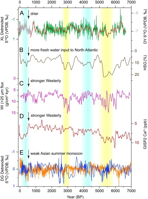
In addition, decreased monsoon precipitation are observed during periods of 5800–4900, 4640–4400, 2950–2680, 1670–1120, and 790–650 a BP. Abnormally reduced monsoon precipitation in the upper Hanjiang River region during periods of 5800–4900 a BP and 2950–2680 a BP correspond to the 5.0 ka and 2.8 ka cold events in the high northern latitude region, respectively. They coincide with notable droughts recorded in different regions of China. Remarkably intensified and southward Westerly jet caused by strong freshwater input into the North Atlantic, together with weakened Asian summer monsoon, might delayed seasonal Westerly jet transition from south of the Tibetan Plateau to the north, and postponed the onset of Meiyu and/or summer rainfall, which resulted in synchronous decreasing of monsoon precipitation in China during the5.0 ka and 2.8 ka events. In contrast, it was wet in the upper Hanjiang River region during the 4.2 ka event and the LIA, similar to the climate conditions in central and southern China, but was opposite of the droughts observed in northern China. Dr. Tan et al. proposed that weak summer monsoon, together with less strengthen or normal Westerly jet may cause rain belt stay longer in the southward region than normal, which reduced rainfall in northern China but enhanced it in central and southern China.
This study was recently published in Earth and Planetary Science Letters. The work was funded by the National Key Research and Development Program of China, West Light Foundation of Chinese Academy of Sciences, and Youth Innovation Promotion Association of Chinese Academy of Sciences.

Fig. Comparison of (A) the detrended XL δ18O record, with (B) ice-rafted hematite-stained grains record from the North Atlantic, (C) (D) Westerly climate index, (E) Asiansummer monsoon intensity records (Imaged by Tan et. al)
Contact: Dr. TAN Liangcheng, tanlch@ieecas.cn, State Key Laboratory of Loess and Quaternary Geology, Institute of Earth Environment, Chinese Academy of Sciences, Xi’an 710061, China
 © 2015 Institute of Earth Environment,CAS
 Address:No. 97 Yanxiang Road, Xi'an 710061, Shaanxi, China

 Location :