
 Location :
The Tibetan Plateau (TP) uplift was the most dramatic tectonic event during the recent geological history of the solid Earth evolution and has been considered as an important driving force for the Earth's climate and environmental change. An increasing amount of geological evidence showed that since the collision of Indian subcontinent and the Eurasian plate (50 Ma ago), the TP might not synchronously uplift as a whole, but uplifted gradually and separately in different sub-regions. Meanwhile, Asian climate and environment has undergone great changes in geological period. But for a long time, opinions about the influence of uplift of the TP on evolution of Asian regional climate and environment are quite different. Based on the geological evidence that the northern TP (NTP) had an uplift of finite magnitude since the Miocene and the major Asian inland deserts formed in the early Pliocene, Dr. LIU Xiaodong and Dr. SUN Hui, from the Institute of Earth Environment Chinese Academy of Science (IEECAS), and co-authors revealed influence of uplift of the NTP and Asian inland deserts information on regional climate and environment by using a high resolution regional climate model through paleo-climate modeling of lowering topography of the NTP and removing Asian inland deserts.
Their numerical modeling results showed the simulated precipitation decreased in a broad lower-altitude zone from the Tarim Basin and Junggar Basin north of the TP to the Sino-Mongolian border region due to the NTP uplift, while increased precipitation was found in the mountains uplifted regions such as the Qilian, Qimantage, and Tianshan Mountians and the Pamir Plateau since the Miocene. Impacts of uplift of different mountains on precipitation varies with season, because the large-scale atmospheric circulation and direction of local prevailing wind changes with season. e.g. The enhanced annual precipitation in the Qilian Mountains and Qimantage Mountains was mainly due to the enhanced northerly winds by the uplift, and the ascending air motion on the northern slops of the mountains during the summer half-year (May-September). Similarly, the increased precipitation in the Tianshan Mountains was mainly caused by the enhanced westerly winds and the corresponding upward motion northwest of the mountains in the summer half-year (December-April) (Figure 1). However, the increase in annual precipitation in the Pamirs was mostly ascribed to the rising of westerly winds on the western slope of the Pamir Plateau. It is the variations of the large-scale atmospheric circulation and local prevailing winds during the rainy season that caused the spatial-temporal differences of precipitation changes induced by the mountain uplift.
Once the TP reached its present-day altitude, the formation of the Taklimakan and other major Asian inland deserts, a product of aridification, would in turn influence local climates, especially by increasing atmospheric stability and reducing precipitation in these desert areas in the Pliocene. For the changes in annual precipitation regionally averaged for the Taklimakan Desert or for the ENWC-WIM desert region, the NTP uplift explained 40 % and the desertification explained 60 % of the total precipitation change in the model responses to both the NTP uplift and formation of the inland Asian deserts. With the uplift of the NTP and development of the Asian inland deserts, the simulated annual atmospheric dust concentration increased in large areas of the Asian inland. Published 11 geological records including the paloe-climate records of pollen, isotope or magnetic susceptibility which can reflect the change characteristic of precipitation in the Miocene are well consistent with the simulated change of precipitation trend, which indicates the NTP uplift and Asian inland deserts formation plays an important role in the long evolution of regional climate change since the Miocene.
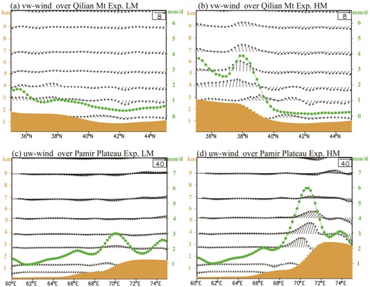
Figure 1 Latitude-altitude transect of summer half-year (May to September) circulation (v and w, Unit: m/s; the w is amplified by a factor 3×10⁶)(arrows) and precipitation (mm/day) (green dotted lines) averaged for the longitudes 98~104°E where the Qilian Mountains are located in Exp. LM (a) and Exp. HM (b), and longitude-altitude transect of winter half-year (December to April) circulation (u and w, unit: m/s; the w is amplified by a factor of 7×10⁶) (arrows) and precipitation (mm/day) averaged for the latitudes 36~39°N where the Pamir Plateau is located in Exp. LM (c) and Exp. HM (d). The shaded areas show the corresponding topography. (Image by LIU Xiaodong)
The study was published in the Quaternary Science Reviews (Liu XD et al., 2015, Impacts of uplift of northern Tibetan Plateau and formation of Asian inland deserts on regional climate and environment, Quaternary Science Reviews, 116, 1-14, doi:10.1016/j.quascirev.2015.03.010)
Further details from Dr LIU Xiaodong: iuxd@loess.llqg.ac.cn, State Key Laboratory of Loess and Quaternary Geology, Institute of Earth Environment.
 © 2015 Institute of Earth Environment,CAS
 Address:No. 97 Yanxiang Road, Xi'an 710061, Shaanxi, China