Located on the northern limit of the East Asian summer monsoon, the Chinese Loess Plateau (CLP) depends largely on summer monsoon precipitation to sustain its agriculture. In addition, as the main sediment source and water-catchment area of the Yellow River, precipitation variations on the CLP are also critical for the water and life securities over the whole Yellow River basin. However, the characteristic and mechanism of decadal scale precipitation variation on the CLP during historical times are still poorly understood. Moreover, the relationship between extreme decadal scale rainfall/drought events on the LP and the water security of the Yellow River remain unclear.
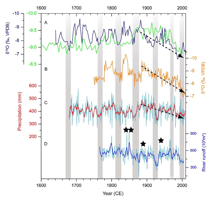
Recently, under the support of the Key Program of the Chinese Academy of Sciences and National Science Foundation of China, Dr. Liangcheng Tan and his colleagues reconstructed high resolution precipitation variation on the western CLP during the past 370 years by using two replicated, annually-laminated stalagmites. Spatial analysis suggests that the reconstruction can be also representative for the whole CLP region. Their records reveal a series of droughts on the CLP during the last 370 years, with a significant quasi-50 year periodicity. They found that the precipitation variations had important social impacts. Drought on the CLP had caused very serious famine and damage to the society in historical times. In contrast, two large-scale land reclamations on the CLP corresponded well to humid periods in their records.
Furthermore, the historical river runoff changes of the middle Yellow River match the stalagmite-inferred precipitation data very well, indicating their close relationship. For instance, when droughts occurred in the 1860s-1870s, late 1920s, 1970s, and the late 1990s on the LP, abnormally low river runoff of the middle Yellow River was observed. In contrast, four megafloods of the Yellow River occurring in 1841-1843, 1855, 1887 and 1938 CE coincided with the humid intervals in this region.
They suggested that the main factor controlling the decadal scale variations and long-term trend in precipitation over CLP is southerly water vapour transport associated with the Asian summer monsoon. The Pacific Decadal Oscillation is also an important influence on precipitation variation in this region.
This study implies that local government have to pay attention to the possible flood in middle Yellow River if the current increasing of precipitation in northern China continues.
The paper was published in Scientific Reports on 16th Sep. 2014. (Tan L. et al.. Cyclic precipitation variation on the western Loess Plateau of China during the past four centuries. Scientific Reports, 2014, 4, 6381; DOI:10.1038/srep06381).
The article online: http://www.nature.com/srep/2014/140916/srep06381/full/srep06381.html
 |
|
Comparison of stalagmiteδ18O records with tree-ring record on the CLP and river runoff record of the middle Yellow River during the past 370 years.(A) WY27δ18O record from Wuya Cave (dark blue) and HY3δ18O record from Huangye Cave (Green); (B) WY33δ18O record from Wuya Cave; (C) Tree-ring based annual rainfall reconstruction from Mt. Xinglong; (D) Historical river runoff reconstruction for the middle Yellow River from Sanmenxia hydrological station.Theblack, broken lines with arrows indicate a decreasing trend of precipitation on the CLP since the end of the 19thcentury. The stars in panel Dindicatefour largeoutburst events of the Yellow River in 1841-1843, 1855, 1887 and 1938 CE. |

 Location :
 © 2015 Institute of Earth Environment,CAS