
 Location :
The Heihe River is the second largest inland river in China.It originates from the Qilian Mountains, flowing through Qinghai, Gansu and Inner Mongolia provinces and converges at the East and West Juyan Lakes. The main course of the Heihe River is 821 km long with a drainage area of 130,000 km2. Annual total runoff is 24.5×10⁸ m3 . The Heihe River watershed is a very important industrial and agricultural region in western China, especially for the Hexi corridor and the Ejin oasis.
However, the water consumption in the middle section was quickly increasing, leading to a sharp decrease of water flowing into the downstream section. Eco-environmental disasters, such as river-lake drying up, tree death in a wide area and frequent sandstorms have aggravated the ecological crisis in the whole Heihe River watershed. It is very important to explore the relationship of the dynamic variations of the water resources with the climatic change, which could yield quantitative information on the history, regularity, and mechanisms of hydrologic variability of the Heihe River over multi-centennial time scales.
Recently, Professor Liu Yu and his research group from Institute of Earth Environent,CAS based on the tree-ring width analysis, reconstructed the total precipitation from previous July to current June of the Qilian Mountains from 1634 to 2000 AD and the average runoff from previous September to current June in the middle section of the Heihe River from 1430 to 2007. This allowed detailed examination of the hydrologic history of the watershed of the Heihe River in western China. Precipitation, runoff and groundwater level were found to be significantly correlated with each other on the decadal scale. The three curves display quite synchronous trends of natural variation before AD 1940 to present before the onset of man-made disturbances. A remarkable period is AD 1925–1940 when the precipitation is low in the upper section, the runoff decreases in the middle section, and the groundwater level declines in the downstream section. After 1940, the groundwater level shows a lag effect, which may be a result of high water consumption in the middle and downstream sections. All three tree-ring based hydrologic indices commonly display the most significant periodicities around 80 (78-82), 50 (49-58) and 2 year. These cycles correspond to large-scale oscillation found in the climate system and appear mainly related to ocean-atmosphere interaction.
In the past 40 years, precipitation increased in the middle part of Qilian Mountains and resulted in increased runoff of the Heihe River, which indicate that the water resource decrease in the middle and lower section of the Heihe River may result from human activities.
The research was published in “Water Research” which is the world famous hydrological journal. (2009 IF=4.355)(Liu, et al., 2010,Tree-ring hydrologic reconstructions for the Heihe River watershed, western China since 1430 AD, Water Research, 44:2781-2792, DOI:10.1016/j.watres.2010.02.013)。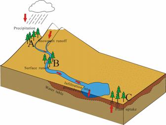
Diagram of the simple relationship among precipitation (A), runoff (B), and groundwater level (C) in the Heihe River watershed (Credit to Liu et al.,)
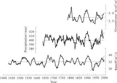
Comparison of the reconstructed precipitation, runoff, and groundwater level in the watershed of the Heihe River (Credit to Liu et al.,)
 © 2015 Institute of Earth Environment,CAS
 Address:No. 97 Yanxiang Road, Xi'an 710061, Shaanxi, China