 Location :
Scientific Significance of Weihe Basin Drilling Project (WBDP)
The Weihe Basin Drilling Project (WBDP), initiated by Academician Prof. AN Zhisheng of the Institute of Earth Environment, Chinese Academy of Sciences (IEECAS), along with nine scientists from the United States, Switzerland, Australia, has recently secured funding from the International Continental Scientific Drilling Program (ICDP). WBDP is a deep-earth exploration initiative designed to address the frontiers of Earth system science in alignment with Sino Probe’s strategy.
After three rounds of rigorous evaluation, the ICDP panel fully endorsed the scientific concept, international team composition, and management framework of the WBDP. With the approval of the ICDP Council, the project received the cap funding allocation of USD 1.5 million requested in the proposal.
Research on deep-sea sediments has highlighted the Cenozoic's most significant global climate transition—from a "greenhouse Earth" to an "icehouse Earth." However, long-term, continuous terrestrial records from continental environments remain scarce, limiting a comprehensive understanding of the characteristics and dynamics of Cenozoic climate change. The Weihe Basin (107º-110º35'E, 34º-35º40'N), located between the Chinese Loess Plateau and the Qinling Orogenic Belt, is highly sensitive to East Asian monsoon climate changes. The basin preserves over 7,500 meters of thick fine-grained fluvial-lacustrine sediments, providing a world-class terrestrial record for studying hydrological and climatic changes in Cenozoic Asia. It is also an excellent site for investigating the climatic history of the Loess Plateau as an ecological barrier.
The WBDP is planned in two phases. Phase 1 (WBDP Phase 1) aims to recover the upper 3,000 meters of sedimentary strata to reconstruct East Asian hydrological and climatic variability on multiple timescales since the late Miocene and its global connections. Phase 2 (WBDP Phase 2) will target the complete 7,500-meter sedimentary record in the basin to unravel the Cenozoic monsoon evolution and its coupling with the uplift of the Tibetan Plateau and Qinling Mountains. A 500-meter pilot core was recently retrieved from the Gushi Depression in the eastern Weihe Basin, based on high-resolution geophysical data and borehole records. This core confirmed that fine-grained lacustrine sediments can reveal orbital-to-millennial-scale hydrological and climatic co-evolution. The ICDP funding will facilitate the completion of the scientific objectives of WBDP Phase 1.
The International Continental Scientific Drilling Program (ICDP), established in 1996 by China, the United States, and Germany, encompasses diverse geoscientific research and aims to promote global collaboration in continental scientific drilling and data sharing. In 2005, the Institute of Earth Environment, CAS, first received ICDP funding to complete the Lake Qinghai International Drilling Project. With the approval of the Weihe Basin Drilling Project, the successful implementation of WBDP Phase 1 is expected to advance the understanding of multi-scale climate change dynamics and provide valuable insights for predicting future climate and environmental trends.
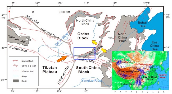
Fig. 1 Tectonic setting of the Weihe Basin and its links to the TP and Ordos Block, and global positioning system velocities (mm/yr, bottom right panel) in and around the Tibetan Plateau with respect to stable Eurasia, plotted on a shaded relief map. (From: Weihe Drilling Team, IEECAS)
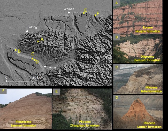
Fig. 2 Typical outcrops of Cenozoic strata. The Cenozoic strata are mainly exposed along the Bailuyuan-Lishan-Changfengyuan on the southern margin of the Weihe Basin. (From: Weihe Drilling Team, IEECAS)
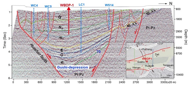
Fig. 3 Proposed drilling site (WBDP-1) in the Gushi depression of the Weihe Basin. Also shown are previous deep boreholes drilled in the Gushi depression for resource exploration. (From: Weihe Drilling Team, IEECAS)
 © 2015 Institute of Earth Environment,CAS
 Address:No. 97 Yanxiang Road, Xi'an 710061, Shaanxi, China